


 Africana55 Radio
This website uses cookies so that we can provide you with the best user experience possible. Cookie information is stored in your browser and performs functions such as recognising you when you return to our website and helping our team to understand which sections of the website you find most interesting and useful.
North Carolina is under a state of emergency, and more than 2,000 people have been evacuated as Hurricane Erin continues to move northward toward the U.S. East Coast.
Tropical storm-force winds and surge conditions are expected to increase in the Outer Banks region of The Tar Heel State and parts of coastal Virginia throughout the evening, according to the National Hurricane Center.
More than 2,000 people were evacuated by ferry from Ocracoke Island, part of the Outer Banks, the governor’s office said, adding that the service "will continue as long as the weather holds.”
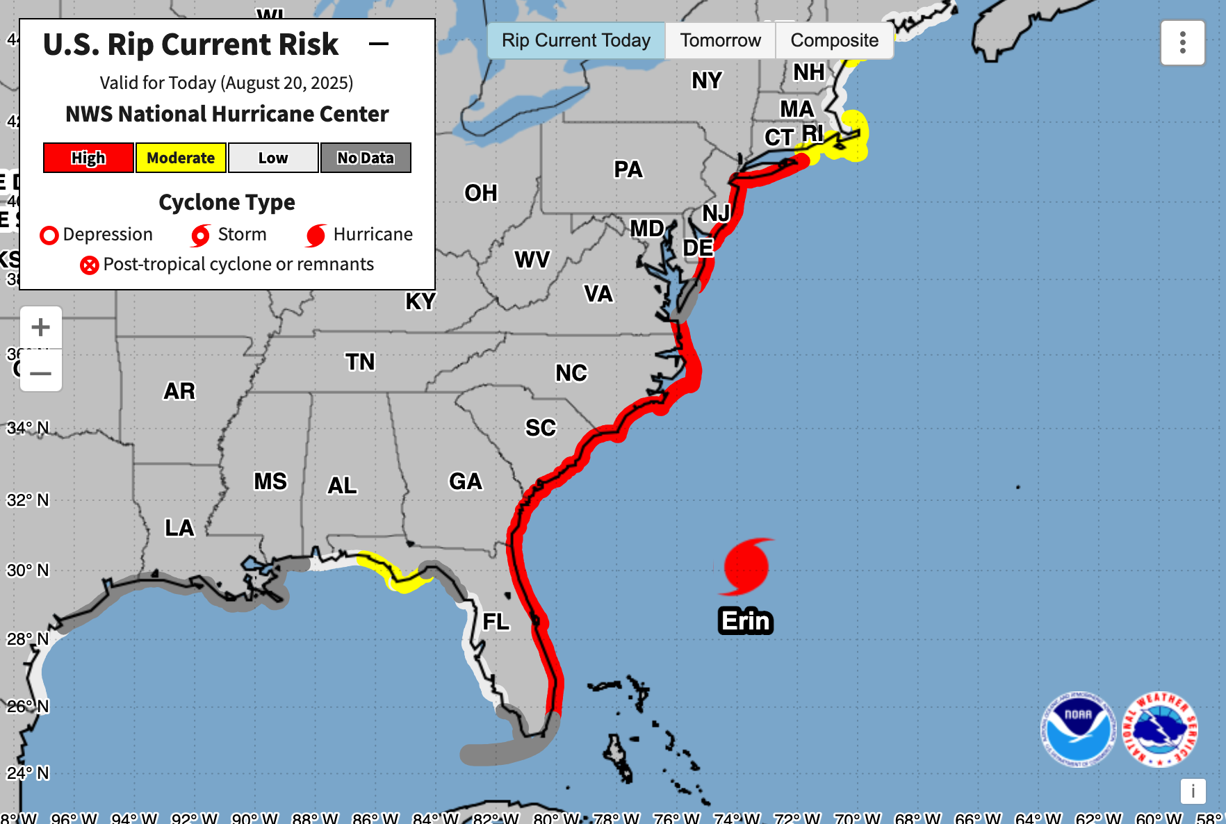
Erin is expected to bring “powerful” waves that could reach up to 20 feet high, along with “life-threatening” surf and rip currents, forecasters warned Wednesday, leading to the closure of beaches all along the East Coast.
The warnings come days after 130 mph winds and torrential rainfall battered the Caribbean and left tens of thousands of Puerto Ricans without power, with Erin later upgraded to a Category 2 hurricane.
The hurricane formed on August 11 from a tropical wave that moved across the Cabo Verde Islands and was upgraded on August 15, becoming one of the fastest-intensifying hurricanes on record.
Spirit Airlines flies directly into Hurricane Erin
A Spirit Airlines flight was tracked flying directly into Hurricane Erin, which was tearing through the Caribbean as a major storm.
On Monday, aviation enthusiasts on Flightradar24 drew attention to Spirit flight NK2298, travelling from Philadelphia to San Juan, Puerto Rico, as it appeared to chart a path straight into the heart of the first major hurricane of 2025. At the time, Erin was battering the Turks and Caicos Islands as a Category 4 system, with winds topping 130mph.
The Airbus A320-271N departed Philadelphia at 1.34pm ET, on course for an early-evening arrival in San Juan. While the number of passengers on board remains unconfirmed, the A320 typically seats between 150 and 180 people.
Despite what appeared to be a harrowing journey through treacherous weather, Spirit Airlines said all passengers arrived safely, with no injuries reported.
“Safety is always our top priority. Our pilots followed procedures and Air Traffic Control instructions while en route to San Juan,” said Tommy Fletcher, senior media relations specialist at Spirit, in comments to the Daily Mail.
The airline added that its Operations Control Centre was monitoring Hurricane Erin throughout the flight, working closely with pilots and air traffic controllers to ensure the plane could safely navigate around or above hazardous conditions.
Stuti Mishra21 August 2025 07:00
Beachgoers asked to follow advisory
Officials have warned residents and visitors to avoid entering the ocean at Wrightsville Beach this week as Hurricane Erin generates dangerous surf and life-threatening rip currents along the North Carolina coast. The no-swimming advisory, issued by the town on Monday, remains in effect until Friday.
However, despite the warning, some swimmers were seen in the water earlier on Wednesday. The beach was temporarily cleared this afternoon when lifeguards detected lightning strikes within 10 miles of the shore.
“These swells are producing powerful rip currents that can create extremely hazardous swimming conditions,” said Sam Proffitt, director of Wrightsville Beach Ocean Rescue, urging the public to adhere strictly to the advisory.
“The safety of our beachgoers is always our top priority, and we urge everyone to follow this advisory.”
Stuti Mishra21 August 2025 06:09
Dangerous waves expected on US beaches until end of week, NHC says
Erin is expected to produce "life-threatening" surf and rip currents in the Bahamas, much of the US east coast, Bermuda, and Atlantic Canada for several days, the National Hurricane Centre has said in its latest advisory.
Tropical storm conditions were already occurring in North Carolina. NHC said the dangerous rip currents will continue through the rest of the week.
Erin is moving north-northeast and is expected to pass between Bermuda and the US East Coast in the next 12–24 hours, then accelerate northeastward across the Atlantic.
Stuti Mishra21 August 2025 05:20
High tides in North Carolina
Powerful winds have pushed waves above the coastline in Buxton, North Carolina, as Hurricane Erin inched closer this evening.
The high tide occurred around 6.10pm local time. and the next one is anticipated between 6 and 7am tomorrow.
Hurricane Erin is tracking north and remains a Category 2 storm, nearly parallel to the East Coast.
Stuti Mishra21 August 2025 04:45
ICYMI: Hurricane Erin caught in stunning 0.5km-resolution imagery
Oliver O'Connell21 August 2025 04:15
NASA wants your photos of hurricane damage — here's why
The space agency, in collaboration with the Global Learning and Observations to Benefit the Environment (GLOBE) Program, a science and education initiative, is spearheading a new Response Mapper project.
Read on for more details...
Oliver O'Connell21 August 2025 03:45
Recap: Hurricane Erin nears the U.S. East Coast
Here’s a look at Wednesday’s developments as Hurricane Erin tracks northwards:
- North Carolina has declared a state of emergency as Hurricane Erin continues its northward trajectory towards the US East Coast, with tropical storm-force winds and surge conditions expected to increase in the Outer Banks and coastal Virginia.
- More than 2,000 people have been evacuated by ferry from Ocracoke Island, part of the Outer Banks, with the service continuing as long as weather conditions allow.
- Forecasters warn that Erin is set to bring powerful waves, potentially reaching up to 20 feet high, along with life-threatening surf and rip currents, leading to beach closures and swimming bans across multiple East Coast states, including North Carolina, Virginia, New Jersey, and New York.
- Despite advisories, some beach-goers in North Carolina were reported to have entered the water at Wrightsville Beach, which was later cleared due to lightning.
- Hurricane Erin, which formed on August 11 and was upgraded on August 15, is considered one of the fastest-intensifying hurricanes on record and previously caused significant power outages in the Caribbean, including Puerto Rico.
- The National Hurricane Center noted Erin as an "unusually large hurricane" and predicted it could strengthen back to a major hurricane by Wednesday evening, with maximum sustained winds near 110 mph, though weakening is expected by Friday.
Oliver O'Connell21 August 2025 03:30
Hurricane Erin mapped: Tracking areas most likely to see the impacts of storm surge and 20-foot waves
Hurricane Erin is spinning its way across the Atlantic toward the U.S. East Coast, but it still appears it's going to swing north and miss a landfall in the lower 48.
Even if the storm doesn't have a direct hit on the East Coast, people living in those areas will still feel the storm's presence in the form of dangerous surf and potential rainstorms.
Graig Graziosi has more:
Oliver O'Connell21 August 2025 03:00
Erin set to strengthen again over the next 24 hours
According to forecasting from ABC News, Erin is currently a Category 2 storm but could re-strengthen later on Wednesday.
The weather system could potentially become a Category 3 hurricane as it tracks between the U.S. East Coast and Bermuda over the next 12-to-24 hours, according to the outlet.
In its outlook, the National Hurricane Center confirmed it was possible that Erin could strengthen and become a “major hurricane” again by Wednesday evening.
The weather system’s maximum sustained winds are near 110 mph with higher gusts, according to the forecaster.
“Some strengthening is possible during the next day or so, and Erin could become a major hurricane again by tonight,” the update said.
Weakening is likely to begin by Friday, but Erin is forecast to remain a hurricane into the weekend.
Oliver O'Connell21 August 2025 02:30
NHC continues to monitor two other areas for possible hurricane formation
The National Hurricane Center is continuing to monitor two other areas of the North Atlantic for tropical system development.
Currently, one system has a 70 percent chance of developing into a storm in the next seven days and is just east of the Caribbean. The other has a 30 percent chance of becoming a tropical storm within the same period and is just west of the Cape Verde Islands.
Oliver O'Connell21 August 2025 02:00